


By Sarah Stebbins
Photographed by Elle Darcy
From our January 2021 issue
After graduating from college in 2001, Orono native Molly Brown loaded up her backpack and headed for some of the world’s most remote places: the central highlands of Peru and Madagascar, Bolivia’s Altiplano plateau, Mongolia’s Lake Hövsgöl, and the Scottish Highlands. In each spot, she’d track down folks involved in a nascent community tourism effort and ask if they’d like her to make them a map — for free.
Brown had a prestigious Watson Fellowship, in which recipients conceive original projects and spend a year pursuing them (thanks to a stipend) outside the United States. A geography major with an artistic bent, she wanted to create hand-drawn maps of rural, mountainous regions with few roads — “tourism frontiers,” she says, where her depictions would have real value. “Cartography resonated with me, but I didn’t love the digital, technical side,” she says. “I always had the art side talking to me.”
It was 10 years — during which time she earned a Ph.D. in geography — before she got serious about engaging those dual passions in conversation again. She and her husband were living in Denver and had just had their first child when Brown, facing new constraints on her time, decided to make her side gig, creating custom maps, her career focus. In 2013, the family moved to Maine. “I had a supportive, fertile landscape here that was calling to me,” she says.


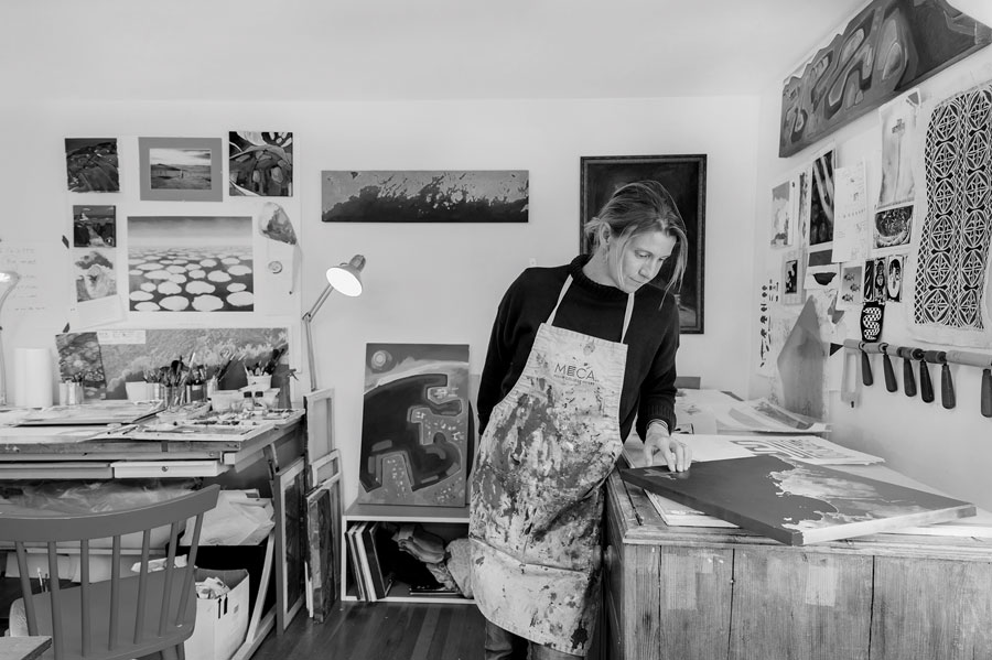
Today, you can find Brown in her Molly Maps studio, in South Portland, creating woodcut prints with puzzle-like coastlines glowing gold against a cobalt sea, watercolor bird’s-eye views of clients’ favorite places, and acrylic landscapes that play with dramatic perspectives. In Raised Along the Penobscot, Maine’s longest river dominates a panorama edged in a mountain-peaked horizon line. In The Owl, Baxter State Park’s boulder-speckled Daicey Pond assumes the convex shape of the earth. “I want you to imagine yourself in the land, but also get the sense that you’re on the planet,” Brown says.
That sense of belonging isn’t so apparent when you cue up Google Earth. Brown says one of the best parts of her job is sharing her approach with kids in map-making workshops. “I tell them, ‘it’s not just satellites and digital data telling your mom’s phone what’s important. What place makes you feel safe? What place makes you feel happy? Let’s put that on a map.’”
TELL US MORE
MOLLY BROWN
When did you become interested in geography?
My freshman year at Middlebury College I opened up the course catalog and was like, let’s try geography. I loved the broad concepts — any question about the spatial reality of our lives you can investigate through geography, including themes like climate change and pollution. I’m a big-picture person and I like big questions.
Did you have any cool jobs before Molly Maps?
When I was in grad school, I worked as an intern in the graphics department at the New York Times. It was the summer of 2005, when the London bombings happened, and I got to do the city map that was on the front page. There’s a lot that goes into how you show data — color, saturation, symbology, scale — that I carry into my work in a looser sense.
How so?
I love the landscape, but I tend to want to do more graphic things with it. Like my painting that shows the part of the Penobscot River that goes through Bangor and Orono — it symbolizes things in very simple ways and it plays with scale. You can see things up close, but it also shows a lot of the river. I’m not stating that it’s accurate, but it’s ac- curate for the story I’m trying to tell.
When you’re not working on commissions, what do you paint?
I have ideas I want to get out of my head. Sometimes it’s a sense of being in a place. It starts when the London bombings happened, andIgottodothe city map that was on the front page. There’s a lot that goes into how you show data — color, saturation, symbology, scale — that I carry into my work in a looser sense. somewhere — a river, a trail — and gets more abstract. Last year, I did a painting of Syrian refugees that shows Greece, Europe, and Africa. I don’t always want to depict pretty places. Our experience on this planet is mixed.
