


Photos by Giant Giants
From our September 2016 issue
On August 24, 2016, one day ahead of the 100th anniversary of the National Park Service, President Obama designated Katahdin Woods and Waters National Monument, an 87,500-acre parcel of mountains, rivers, and forests abutting the eastern edge of Baxter State Park. The land was donated by Burt’s Bees founder Roxanne Quimby, who has advocated for years to establish the site as a national park. President Obama’s executive action, allowed under the Antiquities Act, adds the unit to the National Park Service as a national monument, bypassing the need for Congress to authorize a new national park.
The lands comprising the Katahdin Woods and Waters National Monument are a rugged, underexplored playground for outdoor adventurers — and the years to come will see their further development as a recreation destination. Already, the folks from Elliotsville Plantation, Inc. (EPI), Quimby’s land-stewardship foundation, have been busy cutting trails, clearing scenic overlooks, installing signage, and building new campsites in preparation for the anticipated transition to NPS management. In recent years, Mainers’ debates over the benefits of that transition have been reported ad nauseam. Enough of all that: Here’s how to beat the coming crowds, head up north, and enjoy one of Maine’s unpolished jewels.

What to Expect
The park’s two main features are the wild East Branch of the Penobscot River and a chain of 1,500–2,000-foot peaks in the eastern Katahdin foothills. It’s crisscrossed by some 35 miles of the International Appalachian Trail (a Maine–Canada extension of the famed AT). The property is effectively divided into a northern segment (accessed at Matagamon Gate, 13 miles east of where Route 159 ends in Mount Chase) and a southern segment (accessed via Swift Brook Road from Stacyville). It’s an hour-and-a-half drive from one entrance to the other, via Routes 11 and 159. Right now, entrance is free.
Be warned: Katahdin Woods and Waters National Monument land is not Acadia National Park. It’s not even Baxter. What qualifies as frontcountry are rutted tote roads, for which you’ll want a high-clearance vehicle. Park headquarters is Lunksoos Camps, but it’s little more than a map kiosk, a boat launch, and some handsome-if-humble cabins where a pair of live-in recreation managers field questions. Aside from latrines at a few sites, you’ll find no facilities. Cell service is mostly a fantasy. Exploring the park right now is a backcountry affair — bring a map and compass, plenty of water, a sense of adventure, and a whole lot of bug spray. At the moment, entrance to the monument is free. The NPS has established a headquarters at 20 Penobscot Avenue in Millinocket and runs a seasonal welcome center out of the Patten Lumbermen’s Museum at 61 Shin Pond Road in Patten — but it will likely be months before infrastructure is in place to collect fees. Find more info (including a recreation map) at nps.gov/kaww.
The Highlights
Got a weekend to wander? Here are the marquee attractions you don’t want to miss.
➼ Old Telos Tote Road
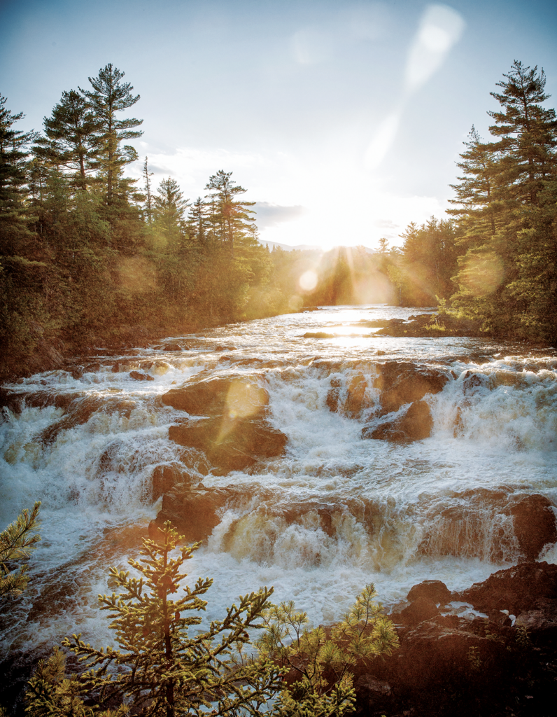
A 4-mile drive from the park’s northern Matagamon Gate, a section of the IAT called Old Telos Tote Road straddles the right bank of the East Branch, taking in five consecutive stretches of tumbling whitewater. “I cannot tell how many times we had to walk on account of falls or rapids,” groused Henry David Thoreau when he paddled this stretch in 1857. Along the trail’s first 3 miles (terrific for mountain bikes, and the site of multiple moose sightings on recent Down East recon trips), the frequent falls make for excellent picnic and rock-hopping spots. Highlights include Haskell Rock Pitch, named for a gnarly 20-foot rock formation rising like a fist out of the middle of the river, and Grand Pitch, a noisy 30-foot cascade that spans the river and churns up a powerful spray. In winter, this area’s trails are groomed for Nordic skiing.
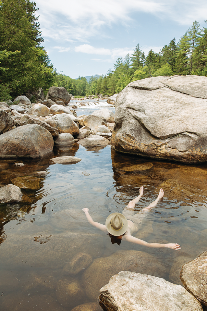
➼ Barnard Mountain and Orin Falls
A short hike with a nice payoff, the Barnard Mountain Trail takes off from mile 12 of the Loop Road, following a wide (and fairly dull) section of the IAT for 1.2 miles. Then the fun begins, a switchbacking climb of .8 miles and 500 feet to a picnic site on a granite outcrop, peering out over Katahdin Lake. Follow the IAT another 2 miles past the Barnard Mountain spur to a junction with the Orin Falls Trail. A rutted, 1.5-mile jeep path leads to the falls — really more of a rapid, spotted with huge boulders that make for great clambering and cozy soaking pools. Pro tip: Except for the Barnard climb, trails are mountain-bike–friendly and more fun on two wheels.
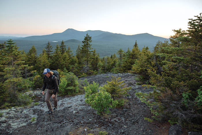
➼ Deasey Mountain
One of Maine’s best (and least travelled) North Woods hikes outside of Baxter, the 9-mile out-and-back trek to Deasey’s 1,964-foot summit starts with a ford of Wassataquoik Stream. Check river conditions, but it’s an easy (if brisk) crossing when the water’s not high. The trail winds past a two-story basalt hunk (known as Earl’s Erratic, for an IAT pioneer) and through noticeably aged stands of spruce, fir, and hemlock. The last mile or so gets aerobic, climbing nearly 900 feet up to a craggy ridge. The summit is marked by a wind-battered and romantic 1929 fire lookout, and the view goes on forever in all directions, taking in Katahdin, Baxter’s Turner mountains, and the prominent northern peaks of Mount Chase and Sugarloaf Mountain.
➼ Katahdin Loop Road
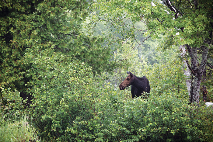
Set aside a couple hours for this 16-mile scenic drive in the park’s southwest corner. The road’s often flanked by thick forest (you may see a black bear scamper out, as we did on a recent visit), but here and there, it skirts exposed mountain ledges with impressive views of Katahdin’s Knife Edge and 4,914-foot Pamola Peak. The mile 7 lookout is the most sweeping, with carved wooden reliefs diagramming the skyline’s panoramic stretch of North Woods peaks. Watch for lumbering moose at aptly named Moose Pond, near the mile 16 marker.

Go Deeper
Farther-flung sites For the intrepid.
➼ Lunksoos Mountain
Tack an extra 2.5 miles on the round-trip Deasey Mountain hike with a side excursion to this neighboring, 1,811-foot peak. IAT signs point the way, following a mostly wooded saddle ridge to another exposed outcrop with postcard-worthy mountain views.
➼ The Lookout
It’s a slog of a 5-mile hike (one-way, with a steep last couple miles) up an old roadway to the nearly 2,000-foot peak known to locals as The Lookout. Knockout views of neighboring Sable Mountain, The Traveler, and South Traveler Mountain. (Mountain bikes welcome, but the going is rough.)
➼ Little Messer Pond
Moose haunt the shallows and loons call across this high-country pond, reached via a short, steep trail from Old Telos Tote Road. Woods are thick to the waterline, but if you can fight through and wade in, the jagged profile of the Travelers is inspiring, reflected in the placid water.
SPONSORED CONTENT
Woodsy Warrior
As forests and wildlife project director for the Natural Resources Council of Maine, Cathy Johnson has worked for years with residents and businesses in the Katahdin region, exploring and promoting the recreation and economic potential of a Katahdin Woods and Waters National Monument. Along the way, she has gleefully camped, paddled, skied, and hiked all across it. We asked what makes the place so special.
What struck you about this landscape early on?
My first impressions were of spectacular views of Katahdin, views from the east that we don’t normally see. Then the river — it’s just amazing. I’m a pretty dedicated paddler, but I’d never been on the East Branch until NRCM started working on this project. I think the variety of paddling is so incredible — this fabulous whitewater at the north end, then you come out and float a lovely current through this great flood plain habitat, spotting moose and eagles.
What might we expect from a national monument’s interpretive aspect?
The National Park Service is great at interpreting the history of the land, and there’s an amazing story to tell about the lumber and paper industry of the North Woods and the Native American presence before that. Plus, Thoreau’s depiction of his trip down the East Branch is colorful and wonderful and should be better known.
If you have friends making a weekend visit, what do you tell them not to miss?
The view from Barnard Mountain towards Katahdin is, I think, one of the best views in the state. You have the blue of Katahdin Lake laid out in front of you, and you’re gazing out on Baxter Peak. You’re standing on Barnard’s beautiful granite ledges, so you get them in the foreground. And it’s not a long trail — I think it’s the kind of shorter hike that many visitors to a national park property are looking for.
How do you envision a new national monument complementing or competing with Acadia National Park?
I worked in Acadia four summers, and a common question there is, “Where can I see a moose?” Well, go up to the national monument for a couple days — see the moose, the incredible river, the beautiful views of the mountains. It really rounds out a Maine vacation. I love Acadia and go there all the time, but I’m much more of a North Woods person. It’s one reason I’m excited about this monument — it’s going to introduce a lot of people to a part of Maine that too few know.
To learn more and help the NRCM protect landscapes like this for generations to come, visit nrcm.org.
The East Branch
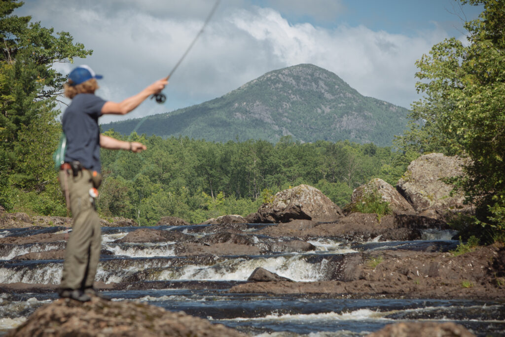
One of Maine’s classic river trips and arguably the state’s best native brook trout fishery, the East Branch of the Penobscot flows out of Grand Lake Matagamon and mostly follows the park’s eastern border. It’s a three-day paddle (26 river miles) from Matagamon in the north to Whetstone Falls on the park’s south entrance road — the first third crazy with whitewater, then the river settles down. A dozen riverside campsites (first-come, first-serve) allow paddlers to make the trip at their own pace. Wading moose, browsing deer, eagles, beavers, and even the occasional lynx haunt the banks. Contact Bowlin Camps (207-267-0884) for guided trips or shuttles.
Camping
“At night,” Thoreau wrote from an East Branch campsite, “the general stillness is more impressive than any sound.” Find such quiet at the primitive campsites (tent pad, fire ring, picnic table) and lean-tos scattered throughout the park, mostly along the IAT and the East Branch. Stand-out spots include Sandbank Stream, a pair of spacious gravel sites (with latrine) next to a moosey and idyllic beaver flowage on Swift Brook Road, and the Grand Pitch Lean-To, a spacious three-walled shelter on the IAT, within earshot of the falls.
As of this writing, sites are free and first-come, first-serve, but campfire permits are required from the Maine Forest Service (207-435-7963). If you’re leaving an unattended car parked anywhere overnight, notify EPI managers (at Lunksoos Camps or [email protected]) with dates, license plate number, and your camping plans — they’ll warn if someone else has already claimed your site. As the unit transitions to NPS management, camping reservation details may change (we’ll update this page in that event), but EPI staff doesn’t expect a fee/reservation system to be in place before year’s end.
Around the Park
“Welcome to the Good Life: Dri-Ki Country” reads a landmark road sign in Patten. East of the park, the rolling landscape of “dri-ki country” (from a northern Maine slang term for driftwood) consists of long rural roads and quiet, spread-out towns. There’s not much (yet) by way of hospitality — restaurants are outnumbered by farm stands selling veggies, chaga, and homemade jams — but a few roadside gems shouldn’t be missed.
➼ Sherman and Staceyville
These adjacent burgs off I-95 have a combined population of 1,200 and access the park’s south entrance. Theriault Flies (1135 Station Rd., Staceyville; 207-365-4007) is a three-room store on Alvin and Connie Theriault’s farm, beloved by North Woods anglers and filled floor-to-ceiling with fly-tying materials — hair from the Theriaults’ own goats, rabbits, and llamas, plus modern tying fibers, wires, and thread. Snag a Maple Syrup fly: tied for years by the Theriaults’ daughter Holly, it’s a suggestive nymph adept at fooling the East Branch’s native brookies. Even if fly-fishing’s not your thing, check out Alvin’s gonzo rock shop, filled with geodes, crystals, carved stone ornaments, and gifts.
➼ Patten
Between the park’s southern and northern entrances, the scrappy Patten Lumbermen’s Museum (61 Shin Pond Rd.; 207-528-2650) is part museum and part encampment, showing off old forestry tools and hulking log-hauling machines. Great photo collection and well-curated bookstore. Families line up at Craig’s Clam Shop (92 Rte. 11, 207-528-2784) for hand-cut fries, fried clam rolls, and a couple dozen flavors of soft-serve (be warned: cash only). Kids can clamber on all sorts of (occasionally avant-garde) equipment at the surprisingly sprawling Patten Community Playground across the street.
➼ Mount Chase
Shin Pond Village (1489 Shin Pond Rd.; 207-528-2900) is a buzzing campground and cabin complex nestled between the lower and upper chambers of its glittering namesake pond (two ponds, really). The store has all basic necessities (s’mores ingredients and beer), and the restaurant serves a mean French toast. Next door, Mount Chase Lodge (1517 Shin Pond Rd.; 207-528-2183) is a bit more genteel. Their beer-and-wine bar + stone fireplace = quintessential North Woods relaxation.
Technically in Township T6R8 WELS, Matagamon Wilderness Campground and Cabins (Grand Lake Rd., 13 miles east of Rte. 159; 207-446-4635) is down the road from Mount Chase. Riverside sites, pay showers, a restaurant, and a fully stocked camp store make it a great basecamp. Plus, there’s ice cream, so it ought to be your first stop after leaving the park’s northern gate.
➼ Millinocket
If you’re combining your trip with a visit to Baxter (good plan), don’t miss hearty breakfasts at the Appalachian Trail Café (210 Penobscot Ave.; 207-723-6720). New England Outdoor Center (30 Twin Pines Rd., 207-723-5438) has cabins and camping and can facilitate about any North Woods trip you can dream up (rafting, fishing, wildlife watching by pontoon). The center’s rustic-mod River Drivers Restaurant has the Katahdin region’s handsomest dining room (plus good poutine and a full bar to boot).
SEE MORE OF KATAHDIN WOODS AND WATERS NATIONAL MONUMENT


