


By Adrienne Perron
Photos by Tara Rice
From our September 2022 issue
I’m walking across the top of the historic Mill Pond dam, in Whiting village, admiring the beauty of the water rushing below, when Jacob van de Sande tells me the nearly 200-year-old stone structure is going to fail. The logs it’s built on are rotted, and at any moment — with an influx of water from a storm, say — the whole thing could collapse, replacing the beloved town pond behind it with a free-flowing Orange River. As van de Sande and I peer down from our apparently precarious perch, watching the falls tumble into the river, he admits that a small part of him hopes it does exactly that.
But the more rational part of van de Sande, a Washington County project manager for the nonprofit Maine Coast Heritage Trust, knows that the dam’s collapse wouldn’t necessarily be a blessing. For starters, the washout would create a hazardous cavern between the dam site and MCHT’s office, which sits just a few hundred feet away. MCHT, a 52-year-old organization known for conserving land and public access on Maine’s coastline and islands, opened its Whiting office almost two years ago, its first in Washington County, in part for the convenience of five local staffers, but also to send a message to the town — that the nonprofit is laying down roots here.
The Orange is one of five rivers at the heart of what MCHT calls its Rivers Initiative, a collaborative effort to protect the health of coastal-river ecosystems, chiefly by restoring fish passage and conserving riparian habitat. Part of restoring the health of the Orange River involves reestablishing its population of anadromous fish — those that are born in the river, travel to the ocean to feed, and eventually return to the river to spawn. Nearly 20 feet high, the Mill Pond dam is untraversable by alewives, salmon, brook trout, and other species that would otherwise be a food source for other wildlife upstream. It’s one of thousands of such impediments to sea-run fish up and down the coast.


The Mill Pond dam hasn’t always obstructed fish passage. Built around 1830, it powered a timber mill until the 1950s, when the mill burned to the ground. Its owners had maintained a fish ladder for nearly a century, but since the fire, no one has invested in the dam’s upkeep, and the fish ladder eventually crumbled. After decades without passageway, anadromous fish populations in the Orange are at historic lows.
So yes, if the dam collapsed, it would offer some immediate benefit to fish and wildlife populations in the Orange River watershed. But the town of Whiting is committed to saving the dam and Mill Pond. Repairing it will cost about $1.5 million; the town has appropriated nearly half of that and hopes federal funds will cover the rest. Removing the dam entirely, meanwhile, would cost about $300,000, and van de Sande says the dam’s current owner, the nonprofit Downeast Salmon Federation, had a donor lined up, ready to shell out to see it gone. But the restoration expense is worth it to the town, in part because the volunteer fire department uses the pond as a water source, but largely because of its scenic and sentimental value. Once the dam is repaired, van de Sande says, MCHT can work with the town to write grants for fish-passage design and construction, which comes with an additional million-dollar price tag. And while fish ladders will never work as well as removing a dam altogether, he says, it’s a step in the right direction.
Van de Sande points down to the dam’s waterfall. Five years ago, he tells me, a member of Schoodic RiverKeepers, one of MCHT’s partner organizations in the Rivers Initiative, put an underwater camera at the foot of the dam, the farthest point on the Orange to which fish can swim from Cobscook Bay. The footage, he says, was of alewives swimming around, looking for some way to continue upriver. “They’re just waiting there,” he says. And sure enough, as we’re standing side by side on the edge of the dam, looking down, I see a splash at the foot of the dam’s symmetrical falls.
“I just saw a fish jump out of the water!” he exclaims. “An alewife just tried to jump over the dam! I’ve never seen that before.”
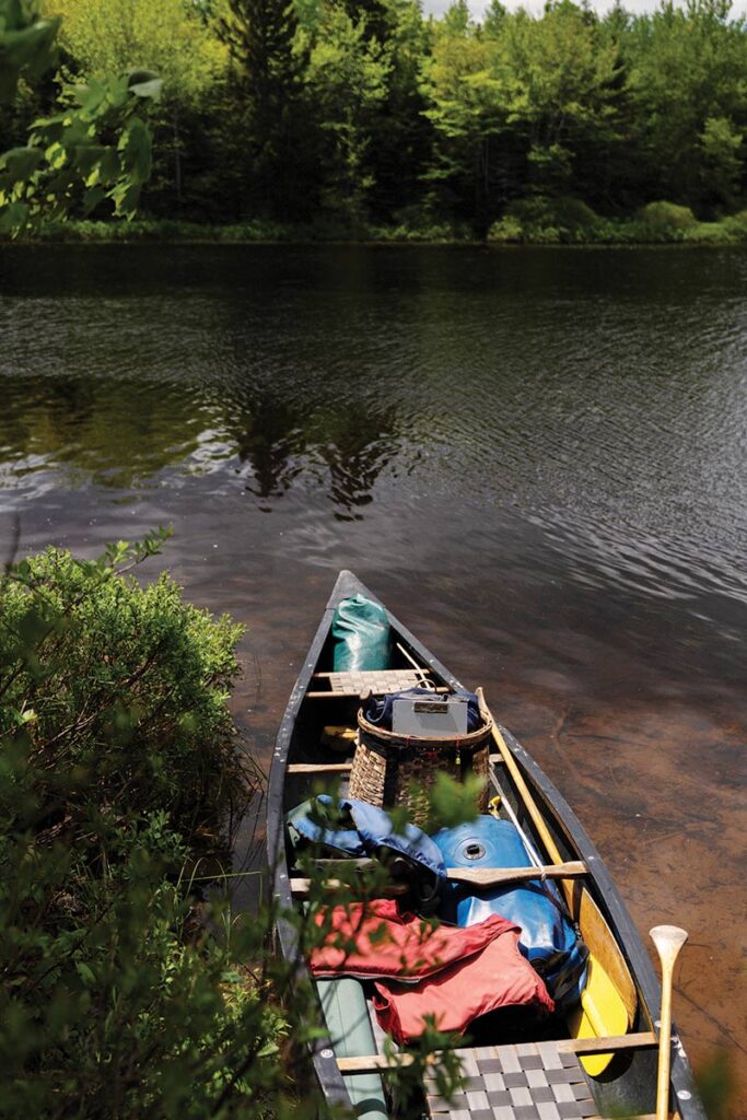
Van de Sande has offered to lead me and photographer Tara Rice on a three-day paddling tour of the Orange River watershed, and we’ve only just put our canoes in, about a mile upstream from the dam, when I realize that I hadn’t expected the river to be so quiet. It’s a gorgeous early-summer morning, very little wind and calm water, and at first, we’re seemingly the only living things on the river — even the bugs are silent as we paddle along. My paddling partner is Cathy Lookabaugh, membership and outreach director for the Downeast Coastal Conservancy land trust, who tells me it’s not unusual to be alone on this river. Honestly, she says, she’s not sure how many people besides locals know about it. The Orange River itself is petite, flowing all of five miles between Orange Lake and Whiting Bay and contained entirely within the town of Whiting, but it is tendriled and linked by marshes and streams to a few backwoods lakes, with only a smattering of camps among them. It is one of the East Coast’s least-developed coastal river systems, Lookabaugh says, and her organization works to keep it that way.
I’m grateful to have Lookabaugh in the stern. I haven’t paddled in years, and guiding newbies is part of her job. Each year, she leads about a dozen paddles on the Orange, part of DCC’s commitment to educational programming, teaching the public about the lands the group acquires and otherwise conserves. DCC is one of more than 20 local partner organizations in MCHT’s Rivers Initiative, pooling resources for projects on each of the campaign’s focus rivers: the Orange, in Whiting; the Narraguagus, which empties out in Milbridge; the Bagaduce, on the Blue Hill peninsula; the Sheepscot, which flows through Wiscasset; and the Mousam, which turns tidal in Kennebunk. From its founding in 1970 until the first stirrings of the Rivers Initiative, in 2014, MCHT focused its efforts on conserving Maine’s coast from development. “But we realized that, if we really wanted to sustain coastal communities culturally, ecologically, and economically, maybe we needed to consider rivers,” van de Sande says. “They are so essential — for ecosystems, because they connect the land and the ocean, but also economically and socially for the communities surrounding them.”

And those communities go back thousands of years, van de Sande reminds me. Long before European settlers altered the river with dams and forestry, the Passamaquoddy used the Orange as a travel corridor linking Cobscook and Machias bays — and the route we’re paddling is part of that ancestral highway. The watershed’s historical significance to Native people is a major reason why MCHT chose to focus on the Orange, van de Sande explains. To help preserve and share that history, MCHT has spent the last several years establishing campsites and clearing portage trails along the route, and starting next summer, the group hopes to begin promoting it as a recreational trail for paddlers, with materials on their website and signage along the trail explaining its importance to the Passamaquoddy.
When most people think about the region’s history, van de Sande says, they think of the centuries since European settlement. The people of Whiting think of the Mill Pond dam and the version of the river it created as a part of the town’s history — and they’re afraid to lose it. What too many overlook, van de Sande thinks, are the thousands of years before, when fish were abundant and the river ran its natural course. “Seven thousand years ago, people fished and wildlife traveled back and forth here,” he says. “We want to get people to look at the broader history, instead of just the last couple hundred years, to look at Passamaquoddy history and open up their idea of what history in this area actually is.”
After a detour into a pretty marsh, where we chase a belted kingfisher that flies and lands ahead each time our canoes approach, van de Sande and Lookabaugh steer us to a spit on the northern bank. It’s the base of Estey Mountain, a 289-foot knoll overlooking the river and in the direction of the adjoining Roaring and Rocky lakes. DCC owns the land and maintains the trail up Estey, part of 700 acres it’s acquired along the river over the last 20 years and one of 15 public-access preserves it stewards in Washington County. The trail is short and sweet, less than a mile long, but van de Sande’s pace is brisk — he talks breezily about the River Initiative the whole way up as the rest of us get a bit winded.


The ledges at the top reward us with views of a seemingly untouched, wild landscape. We can see nearly 20 miles. On the northern horizon, van de Sande points out a portion of Moosehorn National Wildlife Refuge, nearly 30,000 acres of federally protected land. He gestures in the direction of Cutler, where MCHT has conserved 12,000 acres along the Bold Coast, then towards Rocky Lake, where MCHT maintains a 2,284-acre preserve on former timberlands, once slated for development and acquired five years ago with help from the DC-based Conservation Fund. The goal, van de Sande explains, is to create a conservation corridor of linked properties, connecting habitat from the coast to the inland forests. “Connecting people to places, connecting fresh water to the ocean, connecting the landscape together,” he says. “Our work is all about these connections and ensuring that they survive over the long term.”
Of course, the effort isn’t only about wildlife habitat but also human access and recreation: hiking, paddling, hunting, fishing. For van de Sande, who’s trained as a fisheries biologist and spent 14 years stocking rivers for the Downeast Salmon Federation, the pull of the region’s rivers is part of what led him to Washington County, in the ’90s. He hopes that creating more and better opportunities for outdoor rec will help more native down easters see the value — economic and spiritual — of conserving their natural heritage. “Talking about ecosystems and how they function is very esoteric,” he says, “but fish make abstract concepts seem real and tangible. When you improve fish passage and fish come back, when people can go down to the water and their grandkids can have a fish in their hands and can’t stop laughing because it’s wiggling, people understand how this all fits together.”

After Estey, we paddle a few more miles against the wind into Orange Lake, then stop to rest on a sandy beach, where we all lie down and watch a hundred dragonflies catching blackflies and mosquitoes overhead. It’s a heavenly feeling, sprawling out in the sun with the forest behind us. From the beach, it’s a short paddle to a brand-new MCHT campsite, one of three that the group will make freely reservable next summer. After tacos and beers, we make our way to the edge of the water to watch the sky turn from pink to purple. A few ripples in the water suggest fish stirring — likely bass and pickerel, van de Sande says, the latter introduced illegally in the ’90s. He hops into a canoe with his fly rod in hand and stands alone in the boat, casting towards where we’d seen the ripples, until the light fades and it’s time to retreat into our tents. But he never does catch a fish.
The next morning, we take out at a boat launch and lug our canoes across a 1,200-foot portage into Rocky Lake. It’s the smaller of two identically named lakes in the area (the other, confusingly, is 10 miles northwest), but at more than 1,100 acres, it’s five times the size of Orange Lake, forming a ragged, crooked V with Sunken Lake, its westerly appendage. The only shoreline development is a cluster of camps in its southeast corner, near the portage trail. Lookabaugh has gone home, catching a ride from the launch site, and we’re joined instead by MCHT director of land protection Betsy Ham, van de Sande’s boss, and communications specialist Anna Parker, my paddling partner for the day.
Parker encourages me to slide into the sternman position, even though it’s been five years since the only time I’ve steered a canoe. Ham and van de Sande remind me how to J-stroke, to keep the boat heading straight, and despite my trepidation, Parker and I set out, paddling against the wind. After a few minutes spinning the canoe in circles and a few more pointers from van de Sande, we’re making forward progress, and we spot a skiff up ahead. The two fishermen in it are the first people we’ve seen on the water. Van de Sande calls out, asking what they’ve caught. Not much, they say.


Should the town of Whiting find the remaining funds for the Mill Pond dam restoration, van de Sande predicts that the Orange River watershed’s sea-run fish could be restored within five years. The state Department of Marine Resources could begin stocking fish as soon as they know that the town has funding, even before the fish ladder is installed. More fish in the river, particularly keystone prey like alewives, in turn boosts other wildlife populations. Plus, alewives can potentially improve water quality, absorbing nutrient pollution from runoff, via the food chain, then taking that excess nitrogen and phosphorus with them when they migrate to the sea. What’s more, van de Sande predicts, the resurgence of sea-run fish could lead to spikes in groundfish populations in Whiting Bay, a boon to the region’s commercial fishermen. The Bagaduce River, where MCHT and its partners finished installing the last of five fishways last fall, has seen abundant alewife runs throughout the watershed for the first time in decades. Now, van de Sande and his colleagues wait to gauge the impacts there.
“The work we are doing is at a scale where we can test these theories and show the benefits of this fish-restoration work,” he says, “and hopefully it has implications for national fishery policy.”
Patience is a virtue when you work for a land trust, where the work of conservation often involves playing the long game. About 12 percent of the land in the Orange River watershed is conserved by MCHT or its partner organizations — meaning it can’t be built upon, subdivided, or, in most cases, commercially logged, and that public access is guaranteed — and van de Sande and Ham are still building relationships with individual landowners, some of whom have been in communication with MCHT for years, in order to conserve more land. In time, van de Sande hopes, most of the watershed’s lake and stream frontage will be owned by a conservation group or protected through conservation easements and other agreements. MCHT has its eye on a few more pieces of land, he says, including some timberland where he’d like to see working-forest easements established (which prevent development while allowing for timber harvesting).


But the process of convincing a landowner to sell or donate acreage, place an easement, or otherwise limit development can be complicated. Ham tells me about having flown to New York City years ago to meet with an owner of the last unprotected parcel surrounding a locally treasured cove, elsewhere on the coast. The landowners were hesitant to part with the property, as it was where their child had passed away. Ham worked diligently to build trust, and eventually, the owners felt comfortable putting their land in MCHT’s hands, knowing it would never be developed. “Conserving your land is really personal,” Ham says. “Landowners want to be handing it off to people who they trust and can connect with. We laugh together and we cry together.”
Right now, MCHT’s planned paddling trail ends at Rocky Lake, although historically, the Passamaquoddy trail continued into Sunken Lake, then portaged into Josh Pond, to the south, which eventually drains into Machias Bay. But the land surrounding those lakes is privately owned — it’s among 5,000 acres belonging to Saturday Night Live impresario Lorne Michaels. One day, van de Sande and Ham hope to see the entirety of the historic portage trail restored, but they’re in no rush. “Having the luxury of piecing this kind of land together and thinking about it as more than just a quick hike, in and out, is new to us,” Ham says. “We are figuring out how to tell the story of the trail in the best way possible.”
We spend our last night at an old wood-shingled cabin on the eastern shore of Rocky Lake, which MCHT acquired with a land purchase and renovated last year. The Barker Cabin sits a couple hundred feet from the waterline, where it’s rentable for $110 a night to paddle-in guests or accessible by a gravel camp road. With its propane-powered cooking stove, woodstove, wrap-around porch, and a few soft mattresses in a bedroom and sleeping loft, it feels luxurious after two days on the water.
We’re met there by MCHT land steward Melissa Lee, who sits down with us to plates of van de Sande’s from-scratch massaman curry and tells us about her stewardship duties on the Orange River and 11 other MCHT preserves. Lee helped to site and build the three campsites MCHT has established along the Orange, all of which we’ve glimpsed in the last two days and have privies, picnic tables, fire-pits, and beautiful views of the water. Washington County doesn’t have many campsites, and the new sites are some of the first the area has seen in some time — not to mention the first mainland campsites MCHT has ever maintained.


But MCHT has no immediate plans for more cabins or campsites here. Apart from the Mill Pond dam, next steps on the Orange include working with partners to install fish ladders on a pair of smaller, state-owned dams, improving fish passage through culverts, monitoring fish and waterfowl populations, and building some trails and signage. But no time soon will the Orange River be accommodating the visitor traffic of, say, nearby Cobscook Bay State Park. The parking lots at the boat launches are small; the soil on the trails is soft and peaty. The challenge, as is often the case for land trusts, involves balancing the desires to attract and welcome visitors while keeping the experience primitive and pristine. That tension has become even more acute as the pandemic has sent the number of people recreating outside skyrocketing. Lee, a land steward for 23 years, has noticed the boost in traffic on the properties she maintains in Washington County — and with it, more mistreatment of those properties. She’s found human feces and bags of dog poop at trailheads. More visitors are straying off trails and onto the vegetation alongside. “People need trail ethics thrown at them repeatedly,” she says. “They need to be told over and over again what it means to walk on a durable surface. Use the rocks on the trail or step right in the mud puddle in the middle of it.” Some organizations install gravel trails that are more approachable and less destructible, Lee says, but she hates the idea of it. “My conflict is wanting to make trails accessible to people but not harden them to the extent that the experience is gone.”
Nevertheless, she, van de Sande, and their colleagues still believe the future of Maine’s rivers involves getting more people out to see firsthand the rivers’ beauty and how they fit into the bigger picture of connecting land and sea, of enriching communities and sustaining ecosystems. Over the years, the remoteness of Washington County, along with its lack of hospitality amenities, has certainly helped regulate the number of visitors to the Orange River. But the eastward push of overflow visitors from Acadia National Park, looking to explore more beautiful coastal Maine places, is undeniable, van de Sande says. The choice is either to ignore that eventuality or prepare for it by seeing there’s infrastructure to accommodate more hikers, paddlers, and other users — and by making sure roads, gates, and McMansions can’t spoil cherished and critical landscapes.
On our last morning, we’re in no rush to get back on the water — we aren’t excited to leave. We linger outside the cabin, munching on oatmeal and granola bars at the picnic table, enjoying some last peaceful moments on Rocky Lake. When we do get into the canoes, I’m back in the stern, with photographer Tara Rice up front. My J-stroke has improved some since yesterday, and we paddle largely in silence, fully immersed in the experience. As our boat follows in the wake of van de Sande’s, the unspoiled shoreline sliding by, I can almost picture what it would’ve been like to paddle here 7,000 years ago.
